ENB 150 Intro to Environmental Science

Monday, September 3, 2012

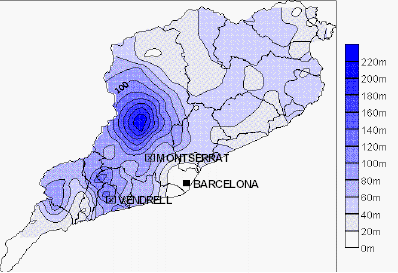
Isopleth maps are used to show elevation, which can help one figure things out such as rainfall patterns. Here is an example.
Posted by Catherine Lee at 8:24 PM
Email ThisBlogThis!Share to XShare to FacebookShare to Pinterest

No comments:

Post a Comment

Newer Post Older Post Home
Subscribe to: Post Comments (Atom)

Blog Archive

  • ▼  2012 (12)
    • ►  December (2)
    • ►  November (3)
    • ►  October (1)
    • ▼  September (6)
      • This is a video of the mile wide tornado hitting...
      • Bathymetric maps are the underwater equivalent...
      • A proportional symbol map uses different sized s...
      • Choropleth maps are used to show variability in ...
      • Isopleth maps are used to show elevation, which ...
      • Dot density maps are used to give a visual of ...

About Me

Catherine Lee
View my complete profile
Picture Window theme. Theme images by epicurean. Powered by Blogger.