Wednesday, December 12, 2012


Mitochondrial dna comes through maternal line. If we didn’t have mutations in DNA, then all of our mitochondrial dna would be identical to that eve. As populations were isolated, we were exposed to different environmental conditions like food, water, climate and we mutated. Pigment changes, propensities to accumulating fat. These are some examples:
Kristi Yamaguchi, a famous ice skater, has very a very typical look of someone with an Asian background-mid colored skin, dark hair and eyes, and a thin eye shape. 
This is the president of the Columbian soccer federation. I watched him lose a game to Ecuador this summer. He has a very typical South American look about him with darker skin and hair. 

These are Mongolian sports players. They have a fuller body shape to provide for colder winters as well as the mid colored skin and more Asian looking face structure. 

Sunday, December 2, 2012

Ocmulgee Lab

Although the Ocmulgee National Monument holds a great cultural value today, it also boasts a rich history. 
In the Early Mississippian period, people living in the Macon Plateau used agriculture to support themselves. They grew mainly vegetables that grew well due to the location. This period lasted from around 900 to 1150 AD.

This culture ended up declining around 1150-1350 in the Early Mississippian Period giving way to the Lamar and Stubbs villages, which mesh the Woodland and Mississippian cultures. Later in the Late Mississippian Period, the Lamar culture did better for themselves. This was around 1350 to 1650. 

Around 1540, the Europeans began their explorations of the area. 


Saturday, November 24, 2012

SOIL.


A soil diagram chart is used to find the percent makeup of soil. By looking at the the percentages of silt, clay, and sand in the soil sample you have, you can classify it. All you do is take the numbers given and follow the corresponding lines to the middle, in which point you will find your classification. 
This is the Munsell Color System. Developed by a professor named Albert H. Munsell, this chart basis its system on the chroma, hue, and value of a sample. 
This image is of the Twelve Orders of Soil Taxonomy. The orders are alifisol, andisol, ardisol, entisol, gelisol, histisol, inceptisol, mollisol, oxisol, spodosol, ultisol, and vertisol. The most common order in Georgia is ultisol with big deposits of alfisol and inceptisol. 

ROCKS.

This is an example of gneiss. Gneiss, a metamorphic rock, is usually formed of the same composition as granite. It usually has bands of color going around it. It is named for its texture rather than its composition. It is a very common rock found where there are or were mountains.
Basalt, pictured above, is an example of an igneous rock. It is formed from the fast cooling of basaltic lava exposed at or close to the surface of a planet or moon. It is made up of less than twenty percent of quartz and less than ten percent feldspathoid. It commonly erupts on earth's moon, Mars, Venus, and even an asteroid. It underlies the earth's surface more than any other rock type. 
This is shale, a sedimentary rock. It is made up of clay minerals mixed with particles of other minerals such as quartz and calcite. It is the most common sedimentary rock, known for its flakey texture. 
Aramayorite is a rare mineral. It is composed tin and bismuth. It can be found in Bolivia. 

Ocmulgee River Lab

Even though I have lived in Macon for three years now, the lab that Dr. Rood led in the Ocmulgee was the first time I have ever been to the river aside from crossing over the bridge above it. While there, we were to do some basic testing. Because we were missing a level, we could not get elevations, but we did get a lot of different clam counts done in different areas of the riverbed as well as a jerry rigged water velocity test with what junk we found in the water.
Though I was not involved in the velocity test, from what I observed, it involved two people standing in two different areas in the river-one upstream and the other downstream with a measured distance in between. The person upstream placed the piece of buoyant trash in the water and let it float downstream while timing how long it took to get from one person to the other. Through that process, they determined the water velocity.
 Using a strainer of sorts, we obtained clam counts from different areas of the riverbed. We looked at areas that were more dry as well as the parts of the bed underwater to see which part the clams preferred. We also took samples from different depths to see how far underneath the clams preferred to live. Looking at the results, the clams preferred the most moist areas of sand to the ones towards the shore.
From what I understand, had we attempted to find the elevation differences, we would have used two long poles with strings that connected them. We would have stuck one pole in the ground and carried the other pole to another point and stick it in the ground. There would have been a level on the string which would have been used to make sure the reading was even. Through that, we would have found the differences in elevation.

Wednesday, October 3, 2012

plants

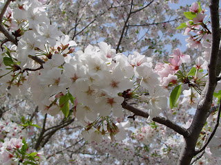
The Prunus x yedoensis, or the Yoshino Cherry tree, is found all throughout Mercer's campus. It's very popular and widespread tree. It comes from Japan and is a hybrid. 

The Hightower Willow Oak, found around the back end of Mercer's campus. According to my sources, the trees grow to be forty to fifty feet tall, and have "lustrous dark green summer leaves." It is from the willow oak genre. 

The Magnolia Grandiflora, or the southern magnolia or bull bay, is very common to the southeastern US. The tree is evergreen and has white flowers.  

Peonie, or paeonia suffricosa, is a plant native to Asia, the southwestern US, and southern Europe. The plant has large flowers of varying colors. 

The tulip, a perennial plant, has many hybrid versions.  

Plumeria, also known as frangipani, is found commonly in the world's tropics. 

Hydrangea, or hortensia, is found commonly in my mother's yard, among other places. 

Baby's breath, or gypsophila paniculata, is a perennial plant. 

Monday, September 3, 2012

This is a video of the mile wide tornado hitting Tuscaloosa last year.

Bathymetric maps are the underwater equivalent of a topographic map. 
A proportional symbol map uses different sized symbols to show data from a particular theme in a certain area.
Choropleth maps are used to show variability in a certain region or how a measurement varies in an area through color and pattern.
Isopleth maps are used to show elevation, which can help one figure things out such as rainfall patterns. Here is an example.

Dot density maps are used to give a visual of the density of something in a certain area. They are inexact, but give a general idea of the quantity.